|
Argolida (Prefecture)

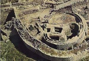
Aerial View of Granary in the Acropolis of Mycenae |
Welcome to Argolida!
If the Peloponnese peninsula were to be seen as a four-fingered hand, Argolida (or Argolis, as it is still also named) would be its thumb. This part of the Peloponnese gives the impression of a completely separate, protected, mysterious and self-sufficient world, as it is surrounded by a line of mountains: Parthenio, Ktenias, Artemissio, Lyrkio, and Trachi to the west, and Oligyrto, Farmakas, Megalobouni, and Psili Rachi to the north.
The Prefecture has a mild Mediterranean climate and a coastline of 230 kilometers (143 miles). There are 53 beaches with a length of over 100 meters (300 feet). Of these 53 beaches, one is characterized by the EU authorities as "bad," one as "good," three as "very good," and the remaining 48 as "excellent." The total length of coastline offered for swimming is appreciated to a total of 56,5 kilometers (34.8 miles), which equals 24,7% of the total coastal length of the region. So, visitors can enjoy a variety of amazing beaches, like the ones of Karathona, Tolo, Porto, Iria, and Salandi. Some are well known, but some still remain untouched and unexplored, as they expand into a long coastline stitched with numerous small bays and capes. Continue
| Argolida: Cities and Towns | | |
| |
|
Argos City, Drepano, Epidavros Town, Mycenae, Nafplion Town, Old Epidavros Town, Porto Heli Village Resort, Tolo Town Resort
|
|
|
|


